Garhwal Himalayas in Uttarakhand also known as Devbhoomi is source of two sacred rivers of India namely Ganga and Yamuna. The rivers and their tributaries meander along the hilly terrain on their journey downstream. A few of the rivers merge together to be called as prayag. Prayags are hugely popular and worthwhile destinations for devout and layman for their religious importance and spectacular views they offer. The high altitude glacial lakes of Garhwal hills – some of them are pilgrimage destinations offering trekkers the pleasure of some adventure which they relish. Few selected water body images from my trips to Garhwal from 2006 through 2011 have been posted as follows.
Image 1
Caption: Devprayag
top view
Description: Merely 74 km uphill from sacred town of Rishkesh,
one gets a spectacular view of Devprayag, which is the confluence of rivers Bhagirathi
and Alaknanda and flows after intermingling in form of Ganga.

Image 2
Caption: Devprayag
a close view
Description: If one has the time in hand, a downward walk along
the steps takes one to the touching distance of water of these
twin rivers.

Image 3
Caption: Rudraprayag
a top view
Description: Further uphill drive of another 70 km brings one to
a place where one gets a grand view of Rudraprayag which is the confluence of
rivers Alaknanda and Mandakini.

Image 4
Caption: Rudraprayg
a close view
Description: If one can grab some more time and go down to the
actual spot of confluence, the view is simply awesome.

Image 5
Caption: Vishnuprayag
Description: Leaving behind Joshimath and traveling 10 km on the
way to Badrinath (30 km from Joshiarth), one definitely takes a break to enjoy
the beauty of the confluence of rivers Alaknanda and Dhauliganga at
Vishnuprayag.

*Image 6
Caption: Nandprayag
Description: Confluence of rivers Alaknanda and Nandakini lies at a distance of 80 km from Badrinath.

Image 7
Caption: Nandprayag
Description: Confluence of rivers Alaknanda and Nandakini lies at a distance of 80 km from Badrinath.

Image 7
Caption: Confluence
of Alaknanda and Saraswati River
Description: Visitors to Badrinath invariably take a 2 km drive
for sightseeing trip to Mana village and come across this wonderful confluence
of rivers Alaknanda and Saraswati.

Image 8
Caption: Karnaprayag
Description: From Badrianth traveling 125 km by road, one
reaches the destination of Karnaprayag - the confluence of rivers Alaknanda and
Pindar. Karnaprayag offers excellent tourist facilities to spend a few days on
hotels overlooking the prayag.

Image 9
Caption: River
Mandakini view at Kedarnath
Description: Source of river Mandakini being from glacier of
Kedarnath mountain peak, the flowing river downstream along the town, makes an
enticing scene of a perfect landscape.

Image 10
Caption: Yamuna
river at Sayanachatti
Description: Sayanachatti is overnight destination for
undertaking next days trek to Yamunotri. The view from steel bridge of roaring
river Yamuna is view to cherish.

Image 11
Caption: Tehri
Dam over Bhagirathi
Description: On the way to Gangotri, one passes through the town
of Utttarkashi and Tehri dam over the river Bhagirathi. The road along the hill
alongside periphery of river Bhagirathi gives a spell binding view of the river
and the dam.

Image 12
Caption: Hemkund
Description: A trek of 7 km from Ghnagaria takes one to Sri
Gurudwara Hemkunt Sahib. The glacial lake surrounded by snow peaks at an
altitude of 15,000’ leaves one awe-struck.
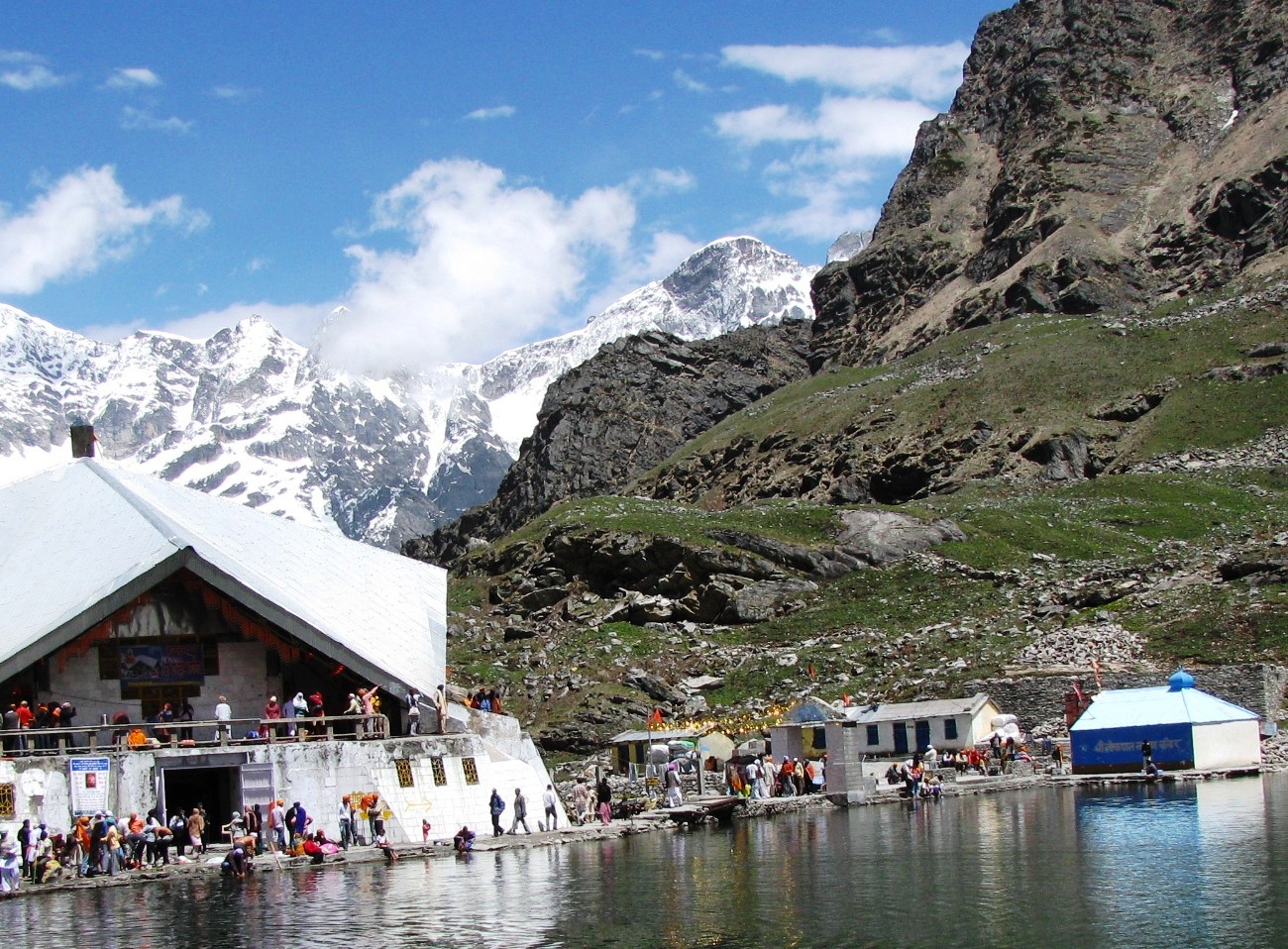
Image 13
Caption: On
way to Valley Of flowers
Description:
A trek of 2 km from Ghangaria takes one to The valley of flowers. River
Pushpavati meanders underneath the snow bridge carrying with it the snow-melt.

Image 14
Caption:
Deoria Tal
Description:
A 2 km trek from the village on Ukhimath – Chopta road takes one to the lovely
lake with the back drop of Himalayan Chaukhamba peak.

Image 15
Caption:
Water discharge
Garhwal being the region of many rivers and their tributaries
flowing down stream at a high velocity, have several big and mini hydroelectric
projects. The frame depicts the tail end discharge from water turbine.

* Image 6 of Nandprayag is captured by Sachin Vaidya.
** For detailed blogs on Destinations on Garhwal Himalayas, readers may log on to my travel blog site:
** For detailed blogs on Destinations on Garhwal Himalayas, readers may log on to my travel blog site:


