Wednesday, 6 February 2013

Captivating Snowscape Images From Uttarakhand


Uttarakhand state has many Himalayan destinations visited by devout and laymen. The Garhwal region of Uttarakhand has religious shrines namely, Kedarnath, Badrinath, Gangotri and Yamunotri, which everybody would like to visit at least once in their lifetime. Devoid of high altitude mountain passes, post winter, the destinations in high altitude regions above 8,000’ are accessible from first week of May. Hemkund route opens in first week of June. I have the pleasure of travelling extensively for last several years in various high altitude destinations of Uttarakhand resulting in large number of snowscape images. Some are posted as below.

Image 1 Caption: Way to Badrinath
Description: The most accessible of Char Dham shrines in Garhwal happens to be Badrinath with road connecting it from Rishikesh. The early summer visitors, around mid-May, will see accumulated snow en route at several locations with rivulet flowing underneath. The image was captured from a running bus as we were approaching Badrinath. 


 Image 2
Caption: Mt. Neelkanth at sunrise
Towering Mt. Neelkanth (6590 m) is visible from almost any spot at Badrinath. One needs to get up early in morning around 5 am and pray for a bit of luck so that clouds would not be obstructing the peak. The sunrise spectacle lasts for more than 15 minutes. Following still image is best I could get from my visit to Badrinath in early summer in May 2006.   


Image 3
Caption: Crumbling snow and the rivulet
Kedarnath is arduous 14 km trek beginning at Gaurikund. My three treks to Kedarnath has resulted in many still images and videos. The topography had a different look in each of the visits. Most memorable visit was in May 2007, when there was too much snow alongside the gorges on trek route after walking 7 km and nearing village Ramwada. In the frame the river Mandakini is flowing alongside a crumbling snow formation.


Image 4
Caption: Between Snow walls at Ramwada
With heavy snowfall in winter and roads being blocked with some 10’ of snow, the snow cutters were used to make a pathway way for the trekkers to walk between two ice walls. A drizzle in afternoon is very common in these regions and poncho (cheap raincoat) is really handy for the Yatris. 
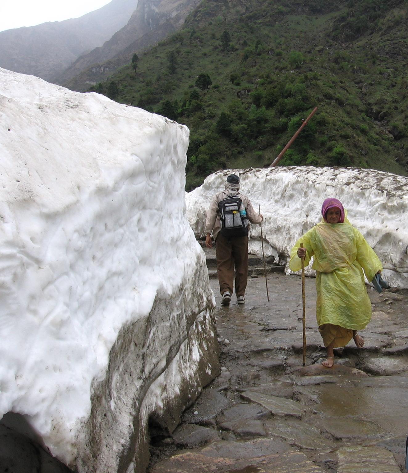

Image 5
Caption: Nature’s largesse
Mother nature poured its largesse rather liberally with huge tract of hill slope covered with snow. With the advent of summer the snow gets crystallized and hardens forming a slippery surface. However that did not deter the villagers frolicking on the white surface. Sheep are perched on rocks in the foreground.


Image 6
Caption: Glacial lake – Gandhi Sarovar
For the adventure seeking yatris to Kedar, there is a 3.5 km trek further up the hill to reach Gandhi Sarovar (Chorabari Tal) at the snout of Chorabari glacier. When we reached the bowl shaped valley, the place was almost completely snow bound revealing a small portion of the glacial lake.


Image 7
Caption: Kedarnath peak
From the Gandhi Sarovar, the Kedarnath peak (also called Kedar massif) appeared quite near as if we could touch it. The bright sun lit day made the visual worthy for capture with a deep blue sky background.


Image 8
Caption: All concentration
Trekking on snow on mountain slopes is best attempted before sunrise. What we could do easily on our onward trek to Gandhi Sarovar through snow before sunrise became an ordeal on our return trek when sun shone real bright. The upper surface of snow melting, negotiating the slippery surface required great deal of concentration to retain the foothold. 


Image 9
Caption: Massive back drop
Yatris commencing their return trek from Kedarnath give a dimension to magnificent Kedarnath peak as a huge back drop. The downhill trek of 14 km is completed in 4 to 5 hours.


Image 10
Caption: Mt. Shivling
Some yatris to Himalayan shrine of Gangotri take to the trek of Gaumukh – source of river Ganges. After almost 7 km of trek and arriving near Cheerwasa, the Himalayan peak of Shivling bathed in morning sunlight and caressed by sparse clouds is a visual delight.


Image 11
Caption: Bhagirathi Massif
As trekkers reach nearer to Gaumukh, the Bhagirathi peak looms larger. The trek route, totally barren and full of stones and boulders of various sizes, last few km is the toughest. The river itself is a small flowing stream, gray in color full of silt.   


Image 12
Caption: Snow-view from Tunganath
Tunganath is one of the Panch Kedar shrines in Garhwal Himlayas at 12,500’ elevation. The 4 km trek through steep gradient stone stitched path starts from Chopta. With clouds lifting its veil and making Himalayan panorama visible after a bout of rain and hail storm.


Image 13 Caption: Snow-peak from Madmaheshwar
Madmaheshwar is one of the Panch Kedar shrines in Garhwal Himalayas. After a bout of snowfall and rainfall in the religious town, the snow-peak make its gorgeous appearance above the cottages scattered around the temple. 

 
Image 14 Caption: Snow-view from Panar Bugyal
Rudranath is one of the Panch Kedar shrines in Garhwal Himalayas. The three and a half days trek from Sagar gives a first night halt at Panar Bugyal ( green meadow ). The snow view in early morning as the yatris come out of their cottage on to the Bugyal is all nature in its pristine glory.


Image 15
Caption: Kedar peak view from Ukhimath
Ukhimath will rank as one of the finest Garhwal destinations. The low altitude makes it a round the year visiting place and gives some of the finest views of Himalayan peaks  like Chaukhamba and Kedar. The following frame was captured from Ukhimath market making way behind the row of shops facing the hgill side.


Image 16
Caption: Mt. Nandadevi view from Auli
Auli is famous skiing resort which one can approach via ropeway or drive a 14 km asphalted road from Joshinath. In summer the panorama of Himalayan peaks is the best attraction for tourists.
The tallest peak is Mt. Nandadevi quite conspicuous by its presence among the lesser peaks.  


Image 17
Caption: Above the snowline
Sri Hemkunt Sahib yatra begins in first week of June after the snow along the trek route of 7 km from Ghangaria is cleared. The yatra is tough but one is rewarded with some of the finest snowscapes he will ever see.


Image 18
Caption: Panchchuli Himalayan peaks
Panchchuli is the formation of five Himalayan peaks in one row and is perhaps seen best from Munshiyari the town in Kumaon region of Uttarakhand.


Image 19
Caption: Tallest of Panchchuli peaks
A close-up of the tallest among Panchchuli peak gives a classic pyramid look in a azure blue sky back drop.


Image 20
Caption: Snow peaks at Binsar
Binsar Wildlife sanctuary is a multifaceted destination in Kumaon region of Uttarakahnd. The end to end panorama of Himalayan range is most enjoyable during sunrise. One gets a simultaneous vision of rising sun and spreading of the golden glow on snowpeaks. 

................................................................................................
 

Thursday, 31 January 2013

Super Snowscape Images From Ladakh


Early summer from end May sees beginning of tourist season to Ladakh. Most of the high altitude passes just having cleared of the snow, vehicles from Leh loaded with tourists start plying to various destinations of Ladakh. My two visits to Ladakh being from end May to early June, the snowscapes could be captured at many destinations as well as on the jeep route. Some selected frames from my collection is presented below.

Image 1 Date: 24.5.2010
Trans-Himalayan range aerial view


 Image 2  Date: 24.5.2010
Snow view From Leh


 Image 3  Date: 24.5.2010
Snow view from Leh


Image 4  Date: 25.5.2010
Snow view between Chotrtens – Shey, Leh


 Image 5  Date: 25.5.2010
Snow view reflection – Shey village


Image 6  Date: 26.5.2010
Changla Baba temple – Chang-la pass


Image 7  Date: 26.5.2010
Lone sentinel at Chang-la


 Image 8  Date: 1.6.2010
Snow peak panorama from South Pullu


Image 9   Date: 1.6.2010
Buddhist temple at Khardung-la


 Image 10  Date:  2.6.2010
Passing through Khardung


Image 11  Date: 2.6.2010
Icicles Galore on way to Khardung-la ( return journey )


Image 12  Date: 2.6.2010
Zig zag path as seen from jeep – beyond Khardung-la


Image 13  Date: 2.6.2010
Rinchen Cafetaria at Kahardung-la


 Image 14  Date: 2.6.2010
Road journey beyond Khardung-la


Image 15  Date: 31.5.2012
Zoji-la on way to Kargil


Image 16 Date: 1.6.2012
View from Rangdum Monastery


 Image 17  Date: 1.6.2012
View at Penzi-la, Zanskar


Image 18  Date: 1.6.2012
Drang Drung Glacier, Zanskar


Image 19  Date: 5.6.2012
View from Namika-la


Image 20  Date: 5.6.2012
View from Fotu-la

.................................................................................................

Monday, 21 January 2013

Luring Landscape Images of Ladakh


The Trans-Himalayan region of Ladakh has no dearth of snow clad Mountains, brooks, meadows and planted trees wherever one traverses. The mountain texture and color is varied with sky tone deep blue in early summer, the opportunity of photo shooting the topography is so enormous that one finds difficult put down his camera for a moment. It is rather difficult to choose the best images out of my collection for posting. Twenty one images have been chosen for this photo essay. Many snow view images have been left out for posting in future for next post under a different photo essay heading. 

Image 1 Date: 24.5.2010
Caption: Soma Gompa & Castle at Tsemo
Description: Leh the capital City and focal point of Ladakh offers the tourists some astounding landscape views from most of the hotels where they are holed up. Soma Gompa & Castle at Tsemo visible on the hill is worthwhile trekking spot, which we kept it for the day after next.   


Image 2 Date: 25.5.2010
Caption: Grandeur On Way to Shey Village & Monastery
Description: After one day of rest and acclimatization, the next day is for half day sight-seeing of Gompas near the city of Leh. On the jeep journey, nearing Shey monastery this captivating view is worthwhile savoring and capturing through the lens.


Image 3 Date: 25.5.2010
Caption: Contrast in topography
Description: This is a close-up view of Image 2. The near and far have a contrasting topography. The eye soothing greenery of the meadows is radically different from barren mudflats in mid-ground and cluster of greenery on foothill of rugged hills to bring up the rear. It is noteworthy to take notice of haze free and pollution free atmosphere in early morning to give a depth to this landscape.


Image 4 Date: 25.5.2010
Caption: Chortens (Stupa) at Shey village
Description: On the way up the stone steps of the Shey monastery, looking down, the view of chortens in one row, surrounded by greenery and backdrop of nearby hill and distant snow clad mountains make a captivating scene.


Image 5 Date: 25.5.2010
Caption: Textured Hill
Description: At the end of tour of four monasteries, driving back to Leh, the hill texture nearby continued to mesmerize us, the distant snow covered hills and blue sky brought up the perfect backdrop. The river Indus make the foreground.


Image 6 Date: 26.5.2010
Caption: Landscape On Way To Pangong Tso
Description: One of the most important jeep safaris which the visitors to Ladakh is not likely to miss is that of Lake Pangong Tso. In early summer one goes through high altitude pass of Chang-la. Beyond Chang-la the hills on both side of the road with milky white frozen water bodies are elements of attraction. The snow peaks make a nice backdrop beyond the textured hills.


Image 7 Date: 26.5.2010
Caption: Crowning glory
Description: Way to Pangong Tso by jeep keeps one glued to varied brown tones of the hills around. A hill with crown filled with fresh snow with a deep blue sky make a picture worth the effort of journeying on the hilly terrain.   


Image 8 Date: 26.5.2010
Caption: Pangong Tso – Distant View
Description: Pangong Tso is viewed from jeep from quite far off between two hills. All the four layers of hills starting from foreground to back ground have different hues and texture worth noticing. The blue water of the lake makes one looking forward to one of the most scenic brackish water lakes in Ladakh.


Image 9 Date: 28.5.2010
Caption: Gompa at Kidmang
Description: On way to lake Tsomoriri a view of Kidmang village in foreground and colorful looking Gompa on hill slope, with element of soothing greenery make an endearing landscape.


Image 10 Date: 29.5.2010
Caption: Nomad’s Land at Korzok
Description: The return trip from Tsomoriri at Korzok was through the pastures of Nomadic land. The shepherds’ tents and sheep scattered in foreground is in stark contrast to the hardened snow patch in mid-ground and snow splattered hill on back drop.


Image 11 Date: 29.5.2010
Caption: Sculptured Hill
Description: The view of a barren rocky hill appears to have been sculptured with a combination of subject matter – a nature’s unique creation.


Image 12 Date: 30.5.2010
Caption: Picture Post Card Beauty
Description: Barely 14 km from Leh takes one Stok village which is one of the most scenic places in Ladakh. The serenity and tranquility of the places charm everybody.


Image 13 Date: 30.5.2010
Caption: Green pathway
Description: The pathway with willow trees leads the eye to distant hills of different texture and hue at Stok village.


Image 14 Date: 30.5.2010
Caption: Way to Hemis National Park
Description: Trekking to Hemis National Park begins at Stok. A few kilometer uphill trek towards base camp of Stok Kangri mountain base is likely to be rewarded with view of wild life.
The lone tented eatery en route with a snow mass left over from winter with back drop of rugged hill greeted us.


Image 15 Date: 30.5.2010
Caption: Way to Stok Palace
Description: A 2 km drive through tree lined Stok village gives an enticing view of Stok Palace, aided by some fluffy white clouds to give a depth to the landscape.


Image 16 Date: 31.5.2010
Caption: Nature’s gate to treasure
Description: The other end of Hemis National Park starts from Zingchen. A trek of couple of km through dried river bed brings one to the opening between two rockey walls for us to squeeze through. Apart from visitors desiring to see wild life this route is taken by adventurous trekkers for Rumbak valley trek. We could not undertake it because of excess snow fall in upper reaches on this trek route.


Image 17 Date: 2.6.2010
Caption: Cold desert
Description: The jeep safari to Nubra valley takes one through the region of sand dunes of Diskit. Diskit along with Hunder are known as the cold desert of Ladakh famous for Bactrian camels with double humps. The wild Bactrian camels nonchalantly walking on sand for a destination of their own come as a surprise live element in this frame.


Image 18 Date: 1.6.2012
Caption: Rangdum Landscape
Description: On my second trip to Ladakh, the focus was Western Ladakh comprising of Suru Valley and Zanskar valley. Starting from Kargil, Rangdum being the first halt at the end of first day at the extreme end of Suru valley. The topography contains meadows, scattered cottages with firewood stacked on top and the distant snow clad hills. The climate was extremely cold plummeting to sub-zero at night.  


Image 19 Date: 2.6.2012
Caption: Passing Through Zanskar Valley
Description: The second day's trip takes one through Zanskar valley passing through Penzi-la pass. Beyond Penzi-la the landscape is serpentine road, water mass and the distant hills. The route terminates at Padum – head quarter of Zanskar region.


Image 20 Date: 5.6.2012
Caption: Lamayuru Monastery Clutching Hill
Description: Kargil to Leh jeep journey gives one to have astounding view of Lamayuru Monastery on the hill side. The vegetation below is in stark contrast breaks the monotony of brown hill and gompa.


Image 21
Date: 6.6.2012
Caption: Rusty Rock
Description: Brown Rocky hills with rust colored coating gives an interesting back drop to the Tak Thog Gompa top as one climbs up.

……………………………………………………………………………………………